This past Monday, January 26, the US Northeast was hit by a monster winter storm. The freak blizzard, nicknamed Juno, is now battering towns and cities along the coastline and threatens to dump record amounts of snow from New Jersey and all the way to Maine.
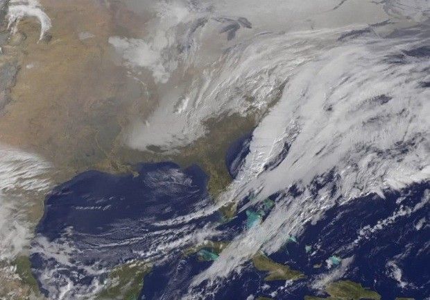
No, really, this storm is a big one. Just scroll down and have a look at the image below to get a better idea of just how monstrous it is. Better yet, take a minute to check out the video showing it form and not-so-slowly creep towards the US coast.
Both the video and the image were obtained with the help of satellites currently orbiting our planet and made public by researchers with the US National Oceanic and Atmospheric Administration (NOAA). Be honest here, this view of the storm quite a sight, isn't it?
The storm will surely be one for the books
As mentioned, it was just yesterday, January 26, that the first snowflakes and strong winds birthed by Juno hit the US Northeast. NOAA scientists expect that, by the time the storm is over, this part of the country's Eastern coastline will be buried under record amounts of snow.
What this means is that about 30 million people might get the chance to make the absolute biggest snowmen ever. Seeing how about 7,000 flights for Monday through Wednesday have been canceled and plenty of roads have been closed, they might just have nothing better to do to pass the time.
Joking aside, it must be said that, on Monday, blizzard warnings were in effect for the coastal areas spanning from New Jersey all the way to Maine. Although not in the storm's path, states located south of Maine were too advised to keep an eye open for extreme weather manifestations.
“Winter storm warning are also in effect for a small area of the Appalachians in west Virginia and Maryland. Winter weather advisories are in effect for much of the mid-Atlantic states and central Appalachians, as well as in the northeast along the western periphery of the winter storm warnings.”
“Winter weather advisories are also in effect for portions of the southern Appalachians in Tennessee, North Carolina and Georgia. Coastal flood warning and advisories are in effect from Delaware to the coast of Maine,” NOAA writes in a statement.
In some areas, the snow will only add up to a few inches. In the regions that will be hit the hardest, on the other hand, the snow cover could reach an impressive 3 feet (nearly 1 meter). In some areas, wind gusts will hit speeds of 50 miles per hour (80 kilometers per hour) and likely cause power outages.
How the storm formed and grew this big
I hate to break it to you, but the fact of the matter is that Juno counts as proof of man-made climate change. As explained by meteorologists, this historic winter storm formed from a front moving southward from the Canadian Prairies and moisture originating from the Gulf of Mexico.
Otherwise put, this perfect storm was created by seriously cold air blowing across the North American continent and somewhat warmer and definitely moister air traveling over the US from the Atlantic Ocean. When these two masses of air got together, moisture in the Atlantic one became snow.
The thing about this moisture that storms need to sustain themselves and that they often dump on one region or another in the form of snow is that, the warmer ocean and sea waters get, the more of it builds up in the atmosphere.
What this means is that, contrary to what some might assume, global warming will not go hand in hand with the demise of massive snowstorms, at least not for several decades to come. Thus, the increase in global waters temperature, and consequently, the increase in the moisture content of the atmosphere stands to birth several massive storms in the near future.
“The developing storm is in just the right position to tap into the high moisture over the ocean and develop as it experiences the sharp contrast between the continent and the relatively warm ocean,” said meteorologist Kevin Trenberth with the National Center for Atmospheric Research in Boulder, Colorado, with reference to Juno.
Tips and tricks to stay safe
First things first, it's important to keep in mind that, whenever there is a blizzard, visibility is reduced to a considerable extent. What this means is that, unless you absolutely have to get someplace, you should stay inside and don't even think about taking your car out for a spin.
Needless to say, you should make provisions and fill your prescriptions before locking the door and getting comfy in your pajamas to wait for the storm to pass. Since strong winter storms can cause power outages, having a flashlight and some batteries close to you might come in handy.
Experts say that those who have no choice but to drive someplace during such a freak weather event as Juno must stay by their vehicle, should they happen to get stuck in the snow. Those who venture in the blizzard on their own risk freezing to death.

 14 DAY TRIAL //


